WP4-16: Difference between revisions
| Line 56: | Line 56: | ||
Another aspect addressed in the context of WP4 is an '''analysis to assess if state-of-the-art deep learning methodologies might provide feasible and advantageous solutions''' for embedded targets. Specifically, the possibility to enhance via AI/ML a currently heuristic functionality integrated '''on the multi-baseline attitude estimation algorithm of GLAD+''' was assessed. | Another aspect addressed in the context of WP4 is an '''analysis to assess if state-of-the-art deep learning methodologies might provide feasible and advantageous solutions''' for embedded targets. Specifically, the possibility to enhance via AI/ML a currently heuristic functionality integrated '''on the multi-baseline attitude estimation algorithm of GLAD+''' was assessed. | ||
The result of these assesment was very promising, since with a limited effort (produce a synthetic dataset, as explained later, design the NN and translation to an embedded target), it was possible to get | The result of these assesment was very promising, since with a limited effort (produce a synthetic dataset, as explained later, design the NN and translation to an embedded target), it was possible to get interesting results in accuracy (without any domain expertise), and an embedded implementation able to work at real-time. | ||
Latest revision as of 15:44, 13 March 2023
| ID | WP4-16 |
| Contributor | ACORDE |
| Levels | Platform, Function |
| Require | GLAD+ platform WP3-15_2 |
| Provide | Navigation data (position, attitude, velocity) |
| Input | Raw sensed data from multi-constellation GNSS receivers, gyroscope and accelerometer data, barometer data |
| Output | Position, Attitude, Velocity |
| C4D building block | |
| TRL | 4 |
| Parent Building block | WP3-15_2 |
| Contact | fernando.herrera at acorde.com |
This page describes the algorithmc improvements brought to GLAD+ by ACORDE in COMP4DRONES, taking as baseline, its outdoor geo-referenced position&attitude system GLAD+.
Description
In WP4 of COMP4DRONES, ACORDE has tackled the enhancement of the navigation software of its low-cost outdoor geo-referenced position and attitude estimation system GLAD+ WP3-15_2.
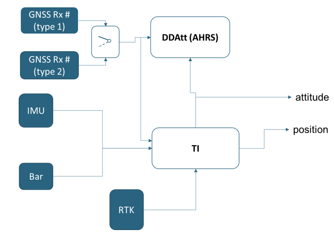
Following figure shows the main architecture of that soluion, i.e. a complex fusion algorithm which integrates raw data from several low-cost GNSS receivers, and from other low cost sensors (gyro, accelerometer, barometer). It consists of two main blocks, in turn, tightly interconnected:
- Tight Integration (TI) fusion block , to yield higher rate, but drift-free geo-referenced positioning data out from the multiconstellation GNSS receivers, and the low-cost sensors
- A Double Differences (DD) based attitude estimation (DDAtt) block able to estimate drift-free, accurate orientation (attitude) data, eventually fusioned with the drift affected orientation provided by the TI block.
Improvements
COMP4DRONES has enable several improvements in the internals of this functionality.
A former acievement was a configurable algorithm that can adapt to different types of low-cost receivers. This is required, as a lesson learned from C4D is that the types of preprocessins (e.g., smoothing, bias adaptations) supported by different low-cost GNSS receiver brands can be very different, which these aspects will have great error impact on the position/attitude estimation unless not considered.
A prominent enhancement of the navigation software has been the exploitation of the novel low-cost receivers integrated in the HW platform developed in COMP4DRONES. The new receivers enable low-cost multi-constellation data, which need to be integrated and exploited in the navigation algorithm. This has been mostly validated for the standard positioning (trilateration) and more specifically, for the TI block of the GLAD+ architecture (more details on D4.3). These receivers also enable specific reactive security features, an aspect also addressed in C4D and further explained in WP5-11_ACO.
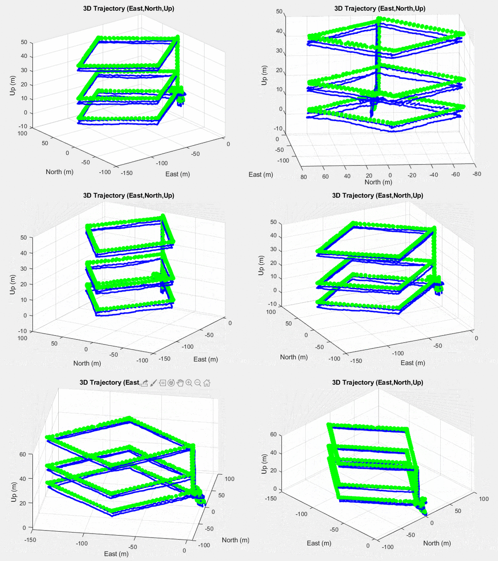
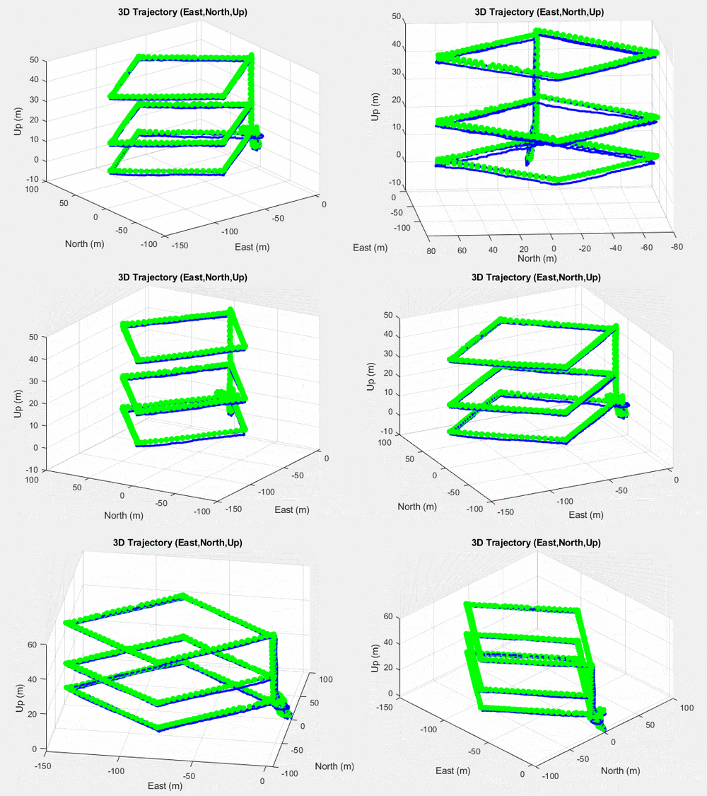
The following figures graphically show the improvement on the accuracy of the low-cost geo-referenced position. The following figures show GLAD+ position output (blue) vs RTK-postprocesed output (green) in one flight test performed in COMP4DRONES in a case where GLAD+ is configured to use only GPS, and in another case where GLAD+ is confiured to use multiconstellation (both GPS and Galileo).
- Accuracy improvement with Multi-Constellation (GPS-Galileo) in one flight test performed in COMP4DRONES
Beyond these graphically apparent example, a systematic analisys on a set of flights of different nature lead to 15%/23.3% average improvements for horizontal/vertical accuracy in static conditions, and 11.9%/31.2 in dynamic conditions.
Another aspect addressed in the context of WP4 is an analysis to assess if state-of-the-art deep learning methodologies might provide feasible and advantageous solutions for embedded targets. Specifically, the possibility to enhance via AI/ML a currently heuristic functionality integrated on the multi-baseline attitude estimation algorithm of GLAD+ was assessed. The result of these assesment was very promising, since with a limited effort (produce a synthetic dataset, as explained later, design the NN and translation to an embedded target), it was possible to get interesting results in accuracy (without any domain expertise), and an embedded implementation able to work at real-time.
Further explanation on the evaluation method are given below, while details are explaines in D4.6 of C4D.
Last, but not least, in the framework of WP4, ACORDE has also provided a "Mavlink interface" to ease SW, and therefore GLAD+ system integration (more details in D4.8).
Validation
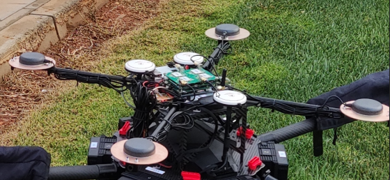
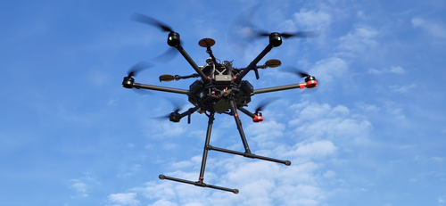
The validation of the improved navigation software has been done by relying on raw data captured with the support of FADA-CATEC, drone integrator&operator partner in Use Case 2 of COMP4DRONES. For that, a former integration test (15/12/2020) was performed, where the multi-antenna setup (shown in the following figure), with the GLAD+ platform and a logger platform which allowed the capture of raw data was tested.
After the integration test, ACORDE, with the support of CATEC, set up test flight for different fligth condtions, considering both, maneuvres that could challenge the positioning system, and feasible operations according CATEC experience (free flight). Those flights took place 2023/01/12.
- Some instants of the test flights
A set of raw catured data, including multi-constellation (GPS-Galileo) observables wehere captured, which served for test the algorithm and even for further refinement and evaluation.
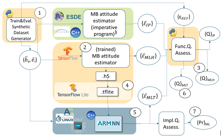
However, this has not been the only mechanism for data generation. In order to serve to all the different research questions posed in C4D, ACORDE has also made a specific set of synthetic data generation, specifically for investigating the possible sustitution of the heurisctic functionality of the attitude estimation algorithm by a trained neural network.
The following figure shows the set up designed for evaluation the benefits of the AI/ML based attitude estimation.
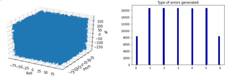
The data feeding this assessment framework was a set of training&evaluation data synthetically generated. The idea was to design this dataset so it were fully representative of the diversity of inputs (baselines) provided to the estimator, and a wide diversity of errors applied to the baselines. For that, baslines where generated directly from a (uniformly distributed) random sample of attitude, plus some (uniformly distributed) random error type. Several error types where described, depending on the number of baselines impacted and the magnitude of the error.
